
With the end of hurricane season about a month and a half away on Nov. 30, the threat from the tropical Atlantic is far from over for the United States. Forecasters are scrutinizing several areas, including one zone in particular that could generate concerns from the Bahamas to the East Coast of the United States during the second half of October.
Already, the continental U.S. has endured a record of 10 land-falling systems of tropical strength or greater during an extremely active hurricane season.
However, in the wake of Delta's devastation in Louisiana, which was still reeling from Laura's destruction, forecasters say the chances of tropical development through the end of this week are low in general over much of the Atlantic basin.
Tropical disturbances, known as tropical waves, will continue to move westward off the coast of Africa every two to three days, but wind shear and dry air will tend to keep these systems at bay and greatly reduce their chance of development. However, there is always a small chance that a system can overcome these obstacles.
"Our outlook for the Atlantic basin shows only a low chance for tropical development of the tropical wave located between 50 and 55 west," according to AccuWeather's top hurricane expert Dan Kottlowski.

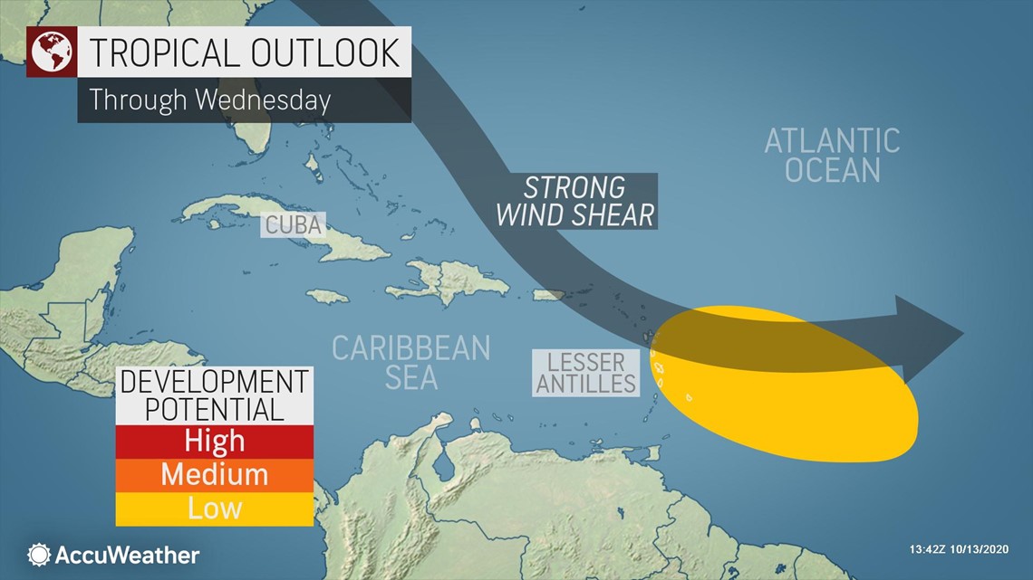
"Showers and thunderstorms along this tropical wave will move over the Lesser Antilles Tuesday night and Wednesday and linger across these islands and expand westward into the Virgin Islands and Puerto Rico Wednesday night and Thursday," Kottlowski said.

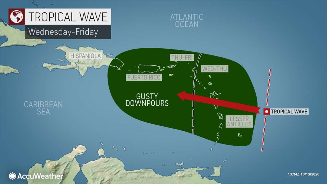
The downpours could be heavy enough to cause isolated incidents of flash flooding as well as rock and mudslides.
A strong tropical wave moving off the west coast of Africa is expected to move westward across the eastern and central North Atlantic during the next few days.
"This far-western Atlantic tropical wave is expected to encounter strong vertical wind shear, and this should prevent tropical development," according to Kottlowski.
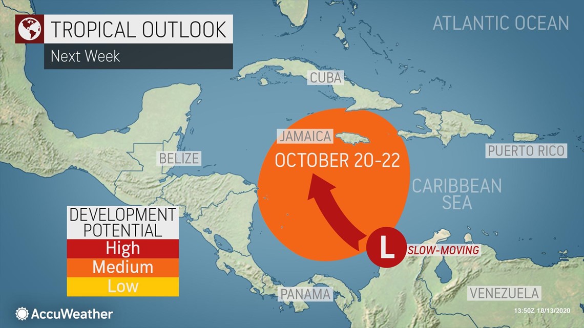
However, it is another area of the basin that may generate bigger concerns. AccuWeather meteorologists expect a broad area of weak low pressure called a gyre to develop over the western Caribbean and Central America next week. A weak spin and rising motion of air is anticipated. Pockets of showers and thunderstorms are expected to ignite in these unsettled atmospheric conditions.

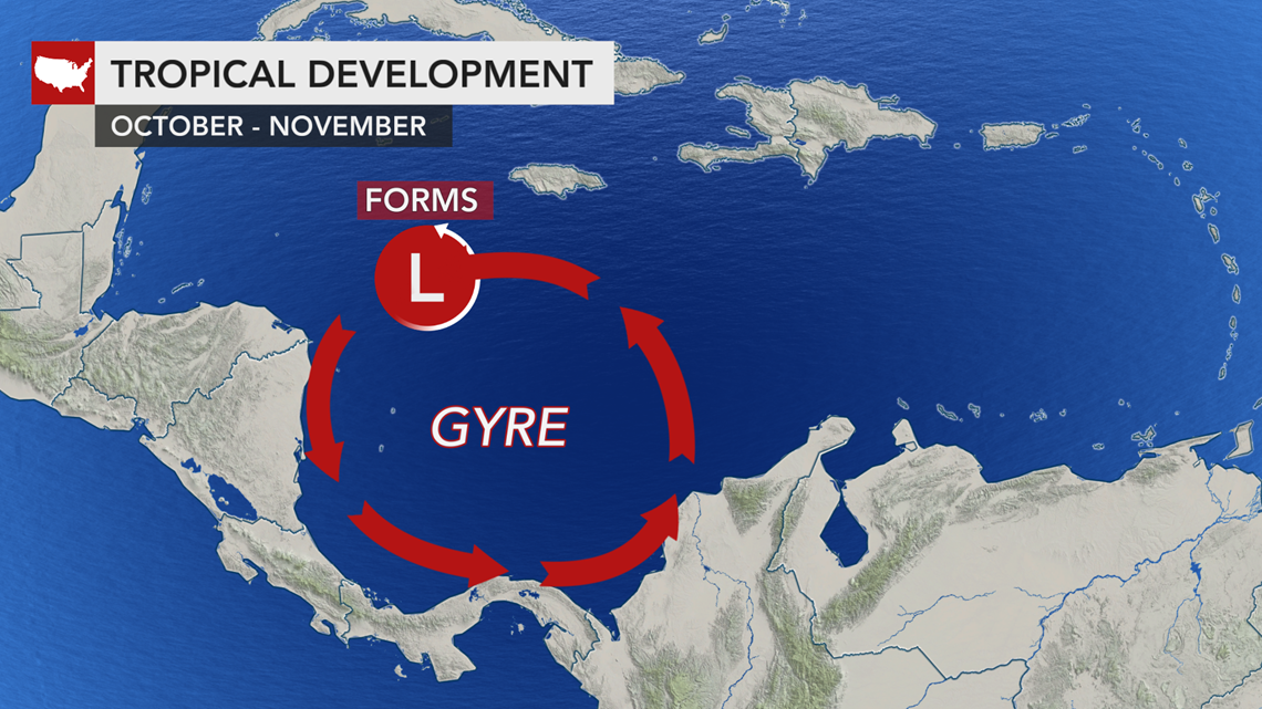
At some point, a tropical wave from the Atlantic or a disturbance from South America may initiate a more compact and stronger area of low pressure within the gyre over the western Caribbean.
"There is the potential for the development of this low pressure area to become an organized tropical system over the central or western Caribbean during the middle to latter half of next week (Oct. 20-22)," Kottlowski said.

At the same time, winds from the west are expected to increase across the central and eastern U.S., which is typical during the second half of October. These westerly winds tend to keep tropical systems away from central and western portions of the Gulf Coast and to some extent away from the East Coast. Sometimes, the westerlies can weaken enough and steering breezes can become more south-to-north orientated, which could allow a tropical system from the Caribbean to move northward and threaten land areas in the eastern U.S.
"Where this particular Caribbean system would track is highly uncertain at this point, and there may be a significant amount of wind shear to the north should the system take a northward path," Kottlowski cautioned.
However, this far out, it's not out of the realm of possibilities that a Caribbean storm could meander northward and become a threat to the U.S.
Late-October powerful hurricanes are not unheard of, including many past tempests that originated in the western or west-central part of the Caribbean and then eventually blitzed across Florida and along the East Coast. Notorious hurricanes that developed in this manner include the ranks of Michael from 2018, Sandy from 2012, Wilma from 2005 and Mitch from 1998.
Forecasters say tropical system behavior near North America during the mid- to late-autumn can be particularly complicated to predict as there is a greater chance for non-tropical systems to become intertwined. Interactions with strong non-tropical systems can pull tropical systems farther to the north and west than what typically occurs during the late summer or early autumn.
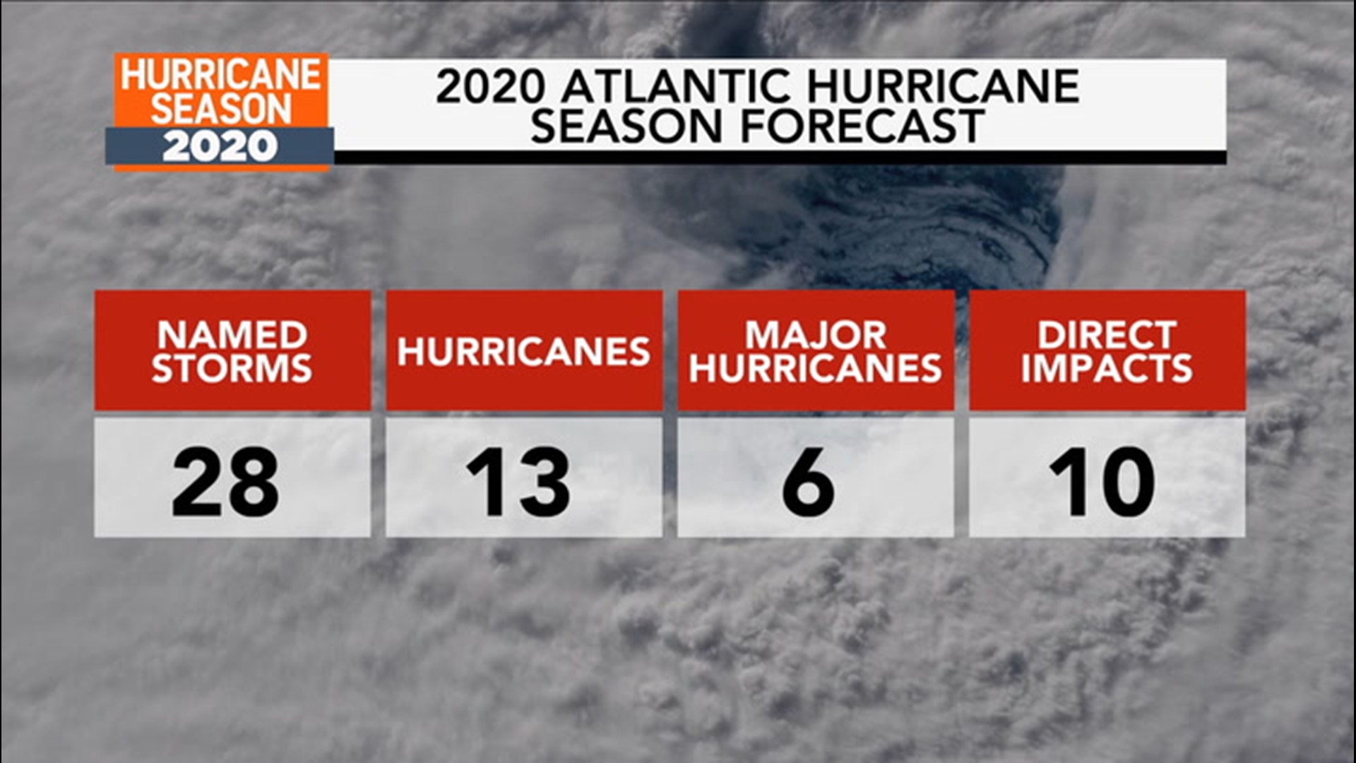
The next tropical storms to form will be given the names Epsilon and Zeta. That's as far as the National Hurricane Center has ever reached in the Greek alphabet in terms of naming tropical systems, and that occurred in 2005. If Eta is used, that would be the first time ever. And, the Atlantic 2020 season is only three named tropical storms away from tying the 2005 record for the most ever to develop in one year, 28 systems of tropical storm strength or greater. The season officially ends in late November, but as was the case with the historic 2005 season, the risk of tropical systems forming well offshore of North America will exist even into December this year.